


1
2
3
4
5
6
7
8
9
10
11
12
13
14
Gallery Additional
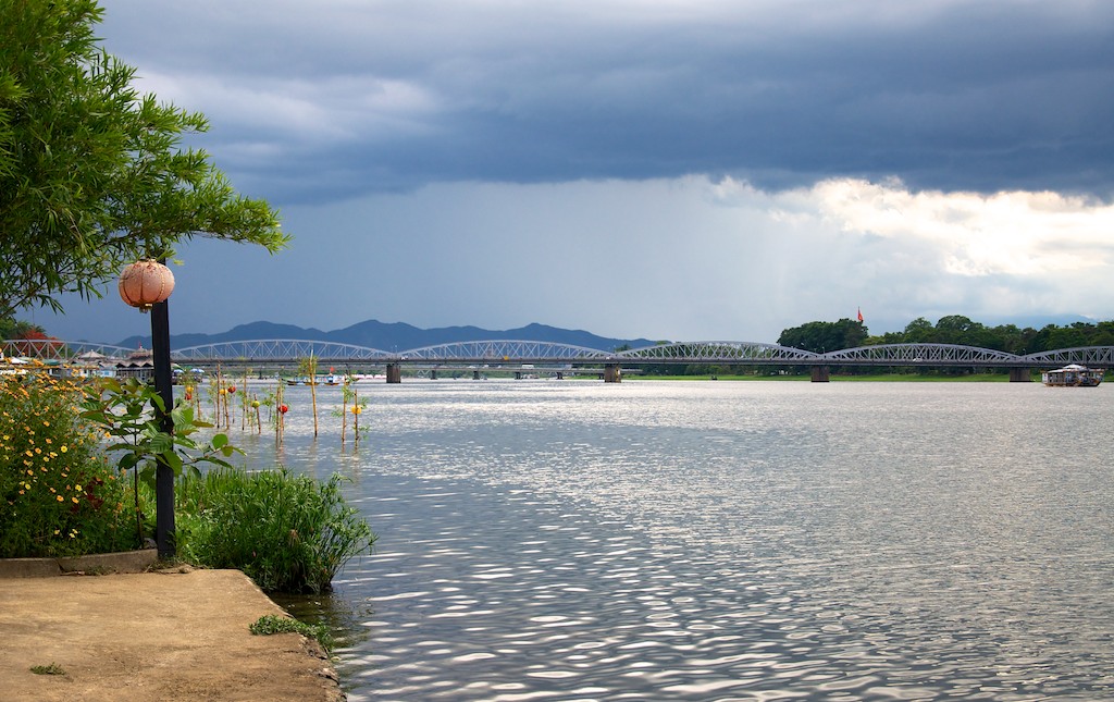
The Perfume River and Truong Tien Bridge, Hue.
The Perfume River and Truong Tien Bridge in the distance, shot in central Hue. During the war, the US used the river and its tributary to move supplies from ships on the South China Sea to a boat ramp in Hue. Supplies were then transferred to trucks for transport to bases inland.
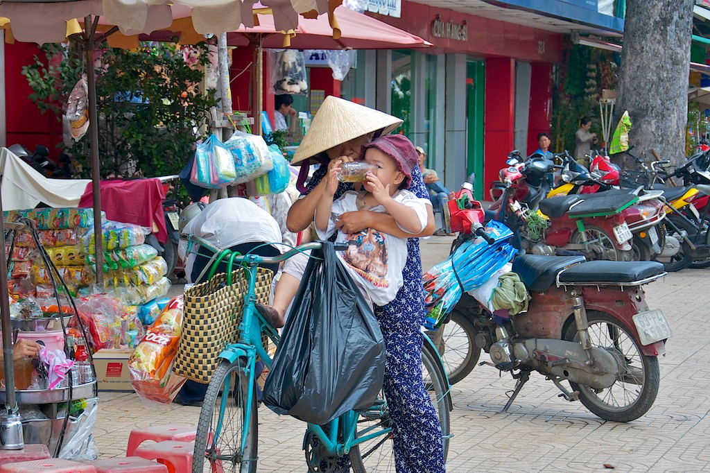
Street Life in Cho Lon, Saigon.
A typical scene of street life in modern Saigon, from Cho Lon, the city's Chinese district. Here on Thap Muoi Street, Cho Lon District, Saigon, a woman gives a baby something to drink. The baby is eyeing the camera carefully. And upon a discerning examination, one will see an eye under the hat, watching as well.
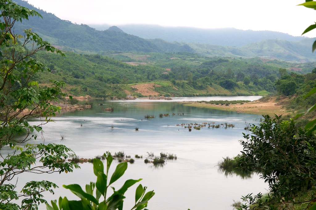
Thach San River, Quang Tri Province.
The idyllic Thach San River in Quang Tri as seen from Route 9. Since the war, a permanent bridge now stands, carrying Highway 14 to its junction at Route 9.
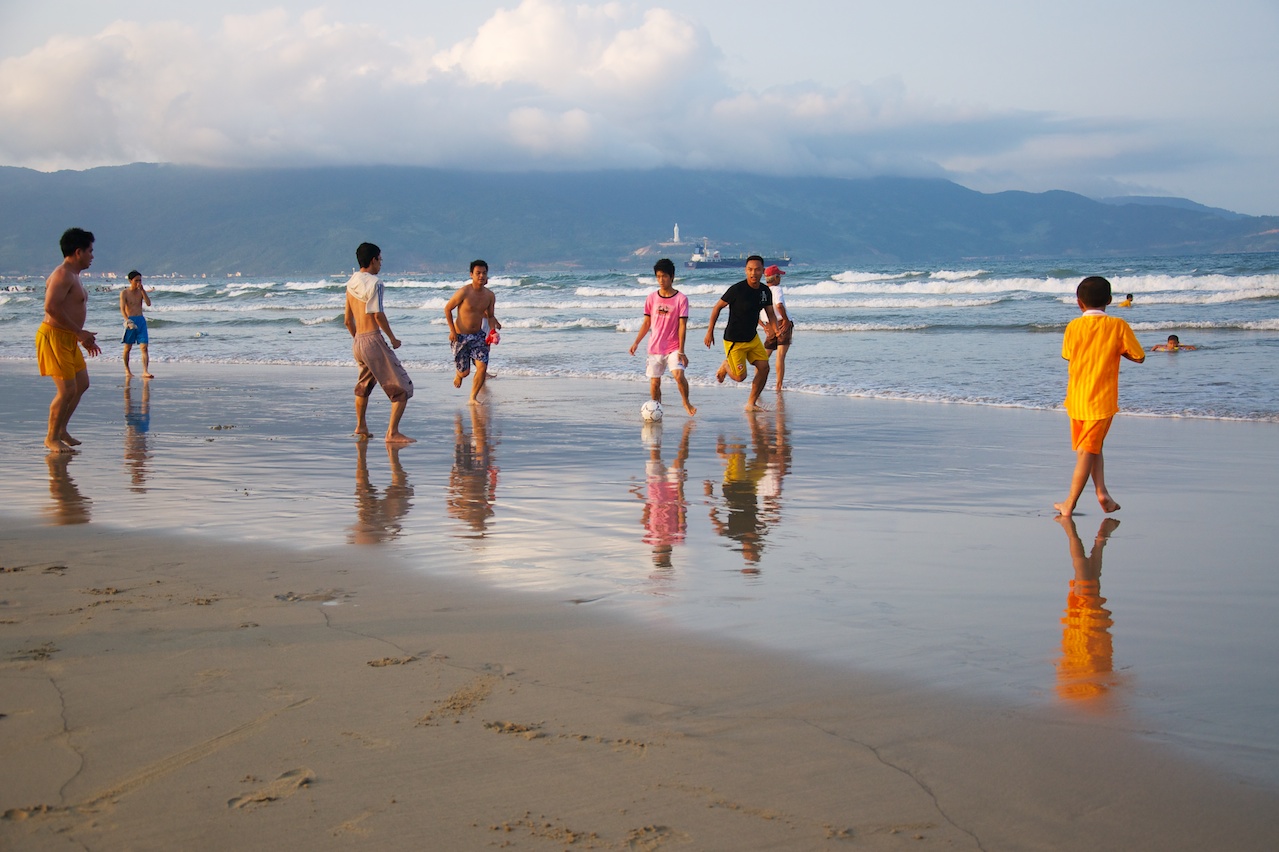
Quy Nhon.
Alleyway off Nguyen Hue Street in central Quy Nhon. Quy Nhon is a coastal city located between Da Nang and Nha Trang. Serving as a major deep-draft seaport, Qui Nhon (as it was previously spelled) served as the primary supply port for all US military operations in the Central Highlands. In addition to port operations, the US Army had support units and a hospital in the city, the US Navy had a logistics center, and the US Air Force had various units at Phu Cat Air Base. Phu Cat, approximately 30 km northwest of the city, has since its capture in 1975, served as a base of the Viet Nam People’s Air Force and more recently, also as the commercial airport for Quy Nhon. Passenger service is available to Ho Chi Minh City (Saigon) and Hanoi by Vietnam Airlines. Here, boys play on the beach with a soccer ball as colorful boats anchor in the bay in the South China Sea behind them
Mai Xa Chanh Village
Familiar transportation in Mai Xa Chanh Village near the DMZ. A woman and three children ride a bicycle in Mai Xa Chanh Village, Quang Tri Province, a few clicks south of the DMZ. This village was the site of the command post for the 2nd Battalion, 4th Marines.
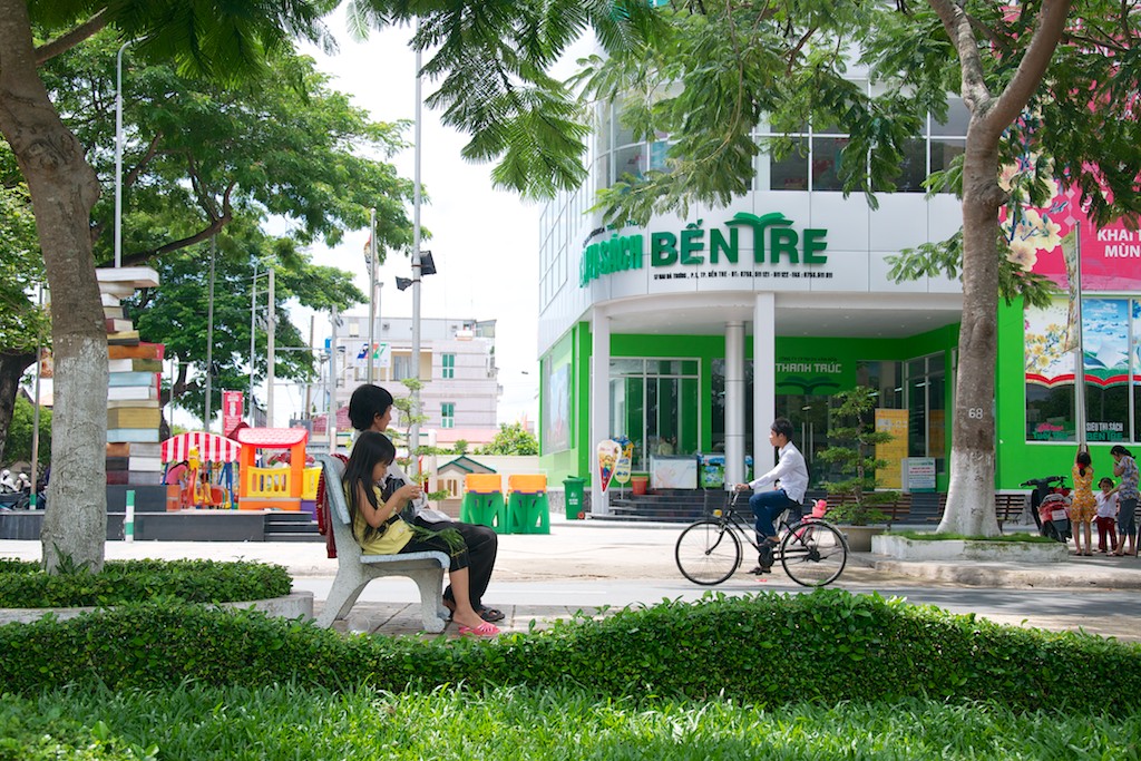
Ben Tre.
Ben Tre. Ben Tre is a quaint little town in the Mekong Delta region, whose destruction during the Tet Offensive gave birth to the famous phrase, “We had to destroy the town in order to save it.” Here's a shot of part of Downtown Ben Tre as seen today.
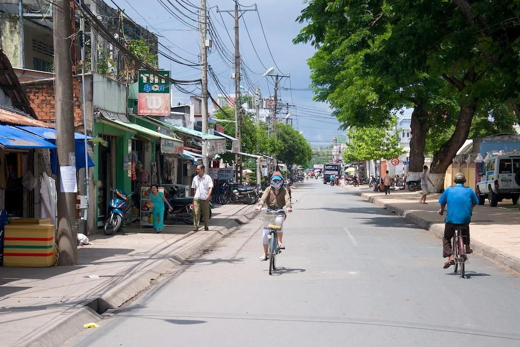
Le Quy Don Street, in Downtown Ben Tre
Le Quy Don Street, in Downtown Ben Tre. Ben Tre is a sleepy little town in the Mekong Delta region whose destruction during the Tet Offensive gave birth to the famous phrase, “We had to destroy the town in order to save it.” Compared to cities further north, in many towns in the Mekong Delta, there are far fewer cars on the roads here proportionately to the population, and bicycles are still very common.
Port of Hai Phong
The Port of Hai Phong was a key US bombing target during the war as it was the main entry point into Vietnam for materiel support for the North Vietnamese and Viet Cong. In 1972 Nixon authorized the US Seventh Fleet to mine the harbor to prevent Soviet and Chinese merchant ships from delivering military supplies to the North. Earlier, Hai Phong had been the primary port used by the US Seventh Fleet during Operation Passage to Freedom to evacuate Vietnamese refugees from the North to the South after the end of the First Indochina War in 1954. From August 1954 to May 1955, nearly 300,000 Vietnamese fled communism through the port. Today, it remains the busiest port in the country, and Hai Phong is the third largest city after Ho Chi Minh City (Saigon) and Hanoi.
Bunkers overlooking the Hai Van Pass between Da Nang and Hue.
Bunkers overlooking the Hai Van Pass between Da Nang and Hue. Used primarily by ARVN during the war, the bunkers kept watch over the vast valley and sea below as the original Highway 1 snaked its way through the Hai Van Pass. These bunkers have since become a tourist attraction as buses traveling the Pass often stop here. As a result, vendors with little shops aimed at tourists have sprouted up across the street.
China Beach.
China Beach. For Americans, China Beach is one of the most famous beaches in Vietnam, as it is often cited as the place where the first US ground forces landed in South Vietnam in 1965. However, the first Marines to arrive on 8 March 1965 did not land here. China Beach was the initially planned location, but military planners changed the landing site days before arrival in favor of a beach in the Bay of Da Nang northeast of the city. The landing beach, known as Red Beach, was preferable because once the Marines landed, they could march or truck from the beach to the airfield without having to cross a river or disturb locals. Had they landed at China Beach, they would have had to cross the Han River as well as populated areas. With the landing of the 9th Marine Expeditionary Brigade on Red Beach, the US committed its first ground troops to Vietnam. 3,500 Marines landed to defend the American airbase at Da Nang, joining 23,000 military advisors already in country. These troops symbolized the beginning of the long and extensive commitment that the United States was to make to the war in Vietnam. During the war, China Beach was a rest and recovery (R&R) location for US forces as well as a major surgical and triage point. Billeting for Marines assigned to the aviation squadrons was also located here. A few kilometers to the south of My Khe, the section of the beach seen here, luxury hotels and villas are being developed, which will join a casino that is already in operation.
Mouth of the Ben Hai River.
Mouth of the Ben Hai River. The Ben Hai River marked the border between the Republic of Vietnam (South Vietnam) and the Democratic Republic of Vietnam (North Vietnam) after Vietnam was divided into two at the Geneva Accords of 1954. Seen here is the mouth of the river as it empties into the South China Sea, shot from the south shore of the river looking north.
Co Giang Street, Saigon.
Co Giang Street, Saigon. A typical street scene in District 1 of Saigon, just outside the core commercial and cultural section of the city, where one would see more cars present.
Vietnam Railways Locomotive at South Long Bien Station, Hanoi.
Vietnam Railways Locomotive at South Long Bien Station, Hanoi. The words “Doi Moi” can be seen on the face of the train. “Doi Moi”, meaning “renovation” was the government’s departure in 1986 from a strict communist economic doctrine, which wasn’t working. After implementation of “Doi Moi”, the economy grew steadily at over 7% per year and entrepreneurialism is now rampant.
An Khe Beauty Salon.
Along one of the main roads through An Khe stands this hair and beauty salon. During the war, An Khe served as the headquarters of the 1st Cavalry Division. At the junction of Highway 19 and Route 674 in eastern Gia Lai Province, though located in Binh Dinh Province during the war before provincial boundaries were changed, An Khe remains a small town today with a population of 63,375 (2009 Census). [Image not in the book but one of thousands shot for this project.]
Vietnam: 35 Years after the Fall of Saigon is a photo documentary of contemporary Vietnam from the perspective of the war, depicting the existing remnants of the war as well as reconciliation and diplomacy that has developed in the post-War years.
Nacala Press | 850 Euclid Ave., Suite 1016, Cleveland, OH 44114, USA